Difference between revisions of "Participation in forest planning in southern Italy"
| (2 intermediate revisions by one user not shown) | |||
| Line 114: | Line 114: | ||
The grid allowed us to schematize and to evaluate, in a synthetic way, complex territorial issues and was used to draw up the list of management objectives drafted by the management responsible for the plan, bearing in mind the results that emerged from the SWOT analysis but also the technical information in their possession (cartography, previous plans .......). | The grid allowed us to schematize and to evaluate, in a synthetic way, complex territorial issues and was used to draw up the list of management objectives drafted by the management responsible for the plan, bearing in mind the results that emerged from the SWOT analysis but also the technical information in their possession (cartography, previous plans .......). | ||
| − | + | [[File:swot0.jpg]] | |
| + | |||
| + | Table 2 – SWOT analysis synthesis grid | ||
Multiple correspondence analysis for farmers. | Multiple correspondence analysis for farmers. | ||
Latest revision as of 13:49, 23 September 2010
General case description
Brief overview
The participatory process was conducted as a part of the forest landscape management plan "Comunità Montana Collina Materana" (Agnoloni et al. 2009, Ferretti et al. 2010). It was produced within the framework of the activities established in the Agreement between the Agricultural Research Council (C.R.A.) and National Institute of Agricultural Economics (INEA) - Headquarters of Potenza (planning organization).
The research was supported by MIPAF (Ministry for Agriculture and Forestry Policy) - National Research Project Ri.Selv.Italia (Subproject 4.2 – Forest Planning - Task: 4.2.6 Study on the implementation of a territory forest planning with participatory approach). Ri.Selv.Italia was a national multi-year research project in the forest-wood-environment sector, promoted by the Ministry of Agriculture and Forests in collaboration with Regions.
The Comunità Montana is the Italian administrative body that coordinates the municipalities located in the mountainous areas and is responsible for administration and economic development. The Comunità Montana Collina Materana, located in the Basilicata region, southern Italy, was chosen as the study area. The territory of the Comunità Montana occupies about 60,784 ha, divided into seven municipalities. The forest areas (12,304 ha) comprise 19.8% of the territory. The large diversity of forest formations is attributed to the great variability in morphology, altimetry and lithology of the area. The demographic density is low, 22.2 people/km², against a national average of 200.1 people/km². The rural sector covers an important role in the economic structure of the Comunità Montana, employing 24% of the active population (national average 8%, European average 4-5%). Conversely, both the industrial and the tourist sectors are extremely weak.
The decision makers were Regional Government and Comunità Montana Officials.
The aims of the participatory process in the project were:
- to perform reflections on the causes and the consequences of the change in the man-forest relationship and on the opportunity to acknowledge new expectations and needs arisen from society towards the forestry sector through participation;
- to define, through study cases, a procedure capable of integrating participation into landscape forest planning and to develop a method suitable for all the different situations in Italy.
The aims of the participatory process in the study case were (Cantiani et al. 2007, Cantiani e De Meo 2007a, Cantiani e De Meo 2007b, Cantiani et al. 2009):
- to evaluate the perception of the forest and of forest management within the local communities;
- to integrate the traditional knowledge with the technical content of the plan;
- to make the population aware of the planning process;
- to carry out the mapping of the stakeholders;
- to involve, through a targeted reach-out, stakeholders who would otherwise not have been able to voice their concerns.
Contents
Organization
Main steps of the participatory process
- 1. context analysis
- 2. stakeholders’ assessment
- 3. planning participation group definition
- 4. method definition
- 5. tools selection
- 6. field survey and data collection
- 7. support systems for data analysis
- 8. evaluation of results
- 9. design of further development
Problem structuring
A participation process was launched based on the consultation by the Planning Participation Group (CRA, INEA, Comunità Montana). The launch of the participation was initially made concrete during the detailed informing of the institutional individuals involved and of the citizens, followed by the consultation phase itself. The local community was involved in the entire planning procedure (from March 2005 to April 2007): from preliminary surveys to the definition of the intervention guidelines of the forest plan policy at landscape level.
Intelligence
Stakeholders
The stakeholders list encompasses 63 participants, grouped into 2 categories, as presented in the table below.
| Category | Stakeolder Group | Nº participants |
|---|---|---|
| Private sector | Associations | 4 |
| Proprieters of accomodation businesses | 5 | |
| Farmers, husbandry activities owners | 27 | |
| Forest operatives | 7 | |
| Woodland firms | 5 | |
| Woodland owners | 3 | |
| Public sector | Mayors | 7 |
| Mountain Comunities | 1 | |
| Corpo Forestale dello Stato (State Forest Park Rangers Corps) | 4 |
The stakeholders list encompasses 63 participants, grouped into two categories, as presented in the table below.
The stakeholders’ identification process was iterative. Starting with institutional respondents, previously unknown representative respondents were also identified. Following the first interviews, the snowball effect ensured that more interviewees were carried out. The main advantage of this type of sampling, known as "Snowball sampling" or "Referall sampling", is its limited cost and sample size.
Objectives Preferences Information
The involvement of the stakeholders was obtained through interviews, aimed at assessing the perception and knowledge of the silvo-pastoral systems, to highlight problems and opportunities and to collect proposals for future land development theories. The questions were formulated according to the following topics: the value and main functions of the woodland; knowledge of the forest value chain and the current situation within the sector; grazing and the relationship between pastures and forest; the potential for agriculture; the value attributed to landscape and perception of changes in the landscape, the population’s bond with the territory; relations between the population and the institutions. The interview, comprised of 132 questions, was submitted to 63 stakeholders subdivided into various categories as shown in the table.
Design
Alternatives
The consultation consisted of the engagement of the institutional players and some stakeholders in work groups to discuss the management strategy outlined in the project’s draft and to jointly finalise the plan. People responsible for the planning process outlined the synthetic managing forms (identified planning proposals), in the form of a draft, in order to submit them to the representatives of the local communities (members of the institutions and some stakeholders). Afterwards these work groups final management strategies were collected in the forest plan.
Choice
Usage of DSS
In the participatory process not a true DSS was used, but two techniques of data analysis were used (SWOT and MCA) to support the elicitation of stakeholder preferences and to identify solutions.
Usage of models, methods and tools
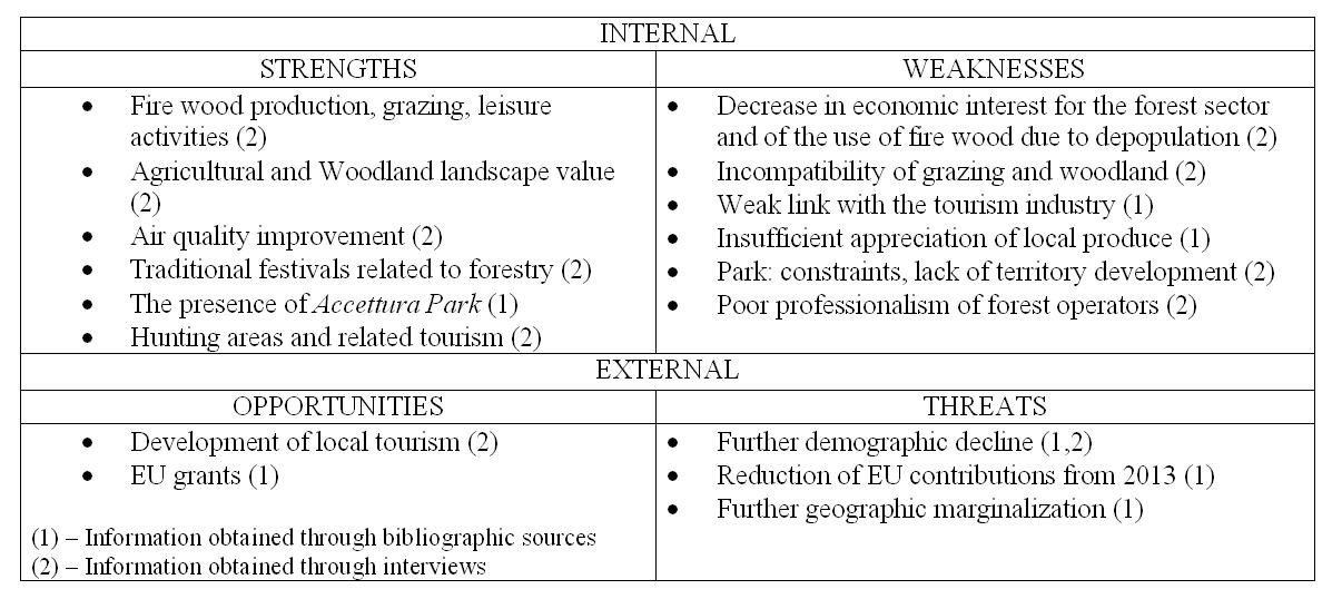
SWOT analysis The SWOT analysis was carried out in the following phases: - the preliminary analysis of the most relevant matters connected to the woodland’s main functions. The analysis was developed by uniting, comparing and reading of the data and information obtained through bibliographic research and that which emerged from the interviews carried out during the consultation phase. - The identification of characterizing factors (strengths and weaknesses, opportunities and threats) and development of the synthesis grid. The characterizing factors linked to the woodlands are summarized in a grid (Table 2) and individually marked according to whether they originated exclusively from the bibliographical research, the sole interviews, or both sources so as to evaluate the importance and the reliability of all the factors in play. - The outlining of a series of synthetic proposals on which to lay out the future development of the territory. The proposals, focusing on the inner strengths of the territory, offer possible alternatives that would be able to counter external factors that present themselves as threats. The strengths listed in the grid (Table 2) revolve around the main functions carried out by the forest formations: fire wood production, landscape purposes, recreational and cultural touristic value. On the other hand, the weaknesses highlight the importance of certain functions which, according to the respondents, are not valued or are difficult to be performed by the woods.
The grid allowed us to schematize and to evaluate, in a synthetic way, complex territorial issues and was used to draw up the list of management objectives drafted by the management responsible for the plan, bearing in mind the results that emerged from the SWOT analysis but also the technical information in their possession (cartography, previous plans .......).
Table 2 – SWOT analysis synthesis grid
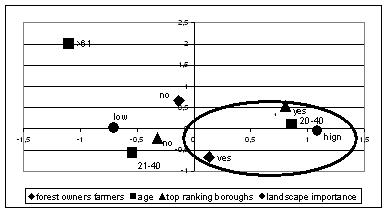
Multiple correspondence analysis for farmers. Farmers and husbandry owners make up the most relevant social group involved in the participatory process. What has emerged, is that grazing strongly conditions the management of woodland and is responsible for conflict between institutional bodies, woodland owners and farmers. The Multiple Correspondence Analysis (ACM) has an exploratory purpose, offering itself to investigate trends and dynamics and then determining “complex categories”: groups of individuals brought together by certain characteristics, identified by certain issues or sharing particular potential. For example, in the “Landscape importance” parameter, the ACM indicates that the landscape is considered important by younger individuals who, besides being farmers, own a certain woodland area and who live in more developed boroughs. Minor importance is given to the landscape by older farmers who live in lesser developed boroughs.
Figure 1- Multiple correspondence analysis for “Landscape importance”
Monitoring
The success of the project was monitored by the Planning Participation Group which was connected to the main stakeholders for the whole length of the process. This exchange of information allowed the Participation Group to monitor the satisfaction of the stakeholders.
References
Cited references
- Agnoloni S, Bianchi M, Bianchetto E, Cantiani P, De Meo I, Dibari C, Ferretti F, (2009). I piani forestali territoriali di indirizzo: una proposta metodologica. Forest@ 6 (1): 140-147.
- Cantiani M.G., De Meo I., Ferretti F., Maino F., (2007). Public participation in forest planning: two case-studies in Italy. Poster presented at the second CIPAST Training Workshop, Procida (NA), 17-21 giugno 2007.
- Cantiani M.G., De Meo I., (2007a). Public participation in forest planning: the case study of Collina Materana (Italy). Oral presentation at the international meeting: forest certification and participation study cases: towards sustainable land use. Trento, 13-14 settembre 2007.
- Cantiani M.G., De Meo I., (2007b). La partecipazione pubblica nel piano forestale territoriale. Oral presentation at the Strategic National Project “Riselvitalia”- Le esperienze nel centro sud Italia: presentazione dei risultati. Potenza, 19-21 giugno 2007
- Cantiani MG, Cantiani P, De Meo I, Ferretti F. (2009). La partecipazione pubblica nella pianificazione forestale: due casi di studio nella realtà italiana. Oral presentation at the 7nd SISEF National Congress "Sviluppo e adattamento, naturalità e conservazione". Università del Molise, Pesche (IS), 29 settembre - 2 ottobre 2009.
- Ferretti F., Di Bari C., De Meo I, Cantiani P, Bianchi M. (2010). ProgettoBosco, a Data-Driven Decision Support System for forest planning. To appear in Mathematical and Computational Forestry & Natural-Resource Sciences (MCFNS).

