Difference between revisions of "Agflor"
Joseborges (Talk | contribs) |
Joseborges (Talk | contribs) (→Decision Support) |
||
| Line 117: | Line 117: | ||
=== Typical temporal scale of application === | === Typical temporal scale of application === | ||
| − | The system | + | The system addresses mostly strategic policy issues |
| − | addresses mostly strategic policy issues | + | |
Revision as of 16:46, 9 October 2009
General System description
System name: Agro-forestry decision support system
Acronym: AGfLOR
Brief overview
AGfLOR is a tool to help assess impacts of policy changes on regional land use patterns
Contents
Scope of the system
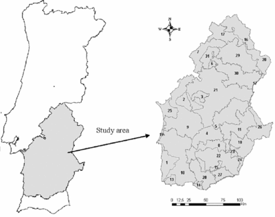
The tool in its current version provides information to assess impacts of Common Agricultural Policy changes on regional land use patterns in Southern Portugal.
System origin
The system was developed in 2007/2008 by the Centre of Forest Studies of Instituto Superior of Agonomia (CEF/ISA) of the Technical University of Lisbon in the framework of Project INTERREG IIIA “Desarrollo de un sistema de información para la gestión ambiental y económica del ecosistema dehesa/montado en Extremadura y Alentejo. 2ª Fase”
AGfLOR is used by the Portuguese Ministry of Agriculture Regional Office of Alentejo (DRAPAL) to assess impacts of Common Agricultural Policy changes
on agricultural and forestry activities and on regional land use patterns over an area extending over 2 million ha.
Support for specific issues
- The system was designed so that it might support the assessment of policy alternatives on agricultural and forestry activities and on regional land use
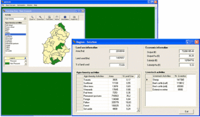
patterns. Its current implementation provides information about impacts of Common Agricultural Policy changes on forestry, agriculture (e.g. cereals, horticulture, fruit culture fruit trees, vineyards, olive trees, permanent pastures, forage, set-aside, fallow), livestock and agro-forestry activities. Namely, it provides information about changes in area occupied by each activity, and in physical production and revenues resulting from each activity.
- The user may specify the policy changes, product prices and supply elasticity, and subsidies for each agroforestry and livestock activity to
assess its impacts on regional land use patterns.
Support for specific thematic areas of a problem type
- Development choices / land use zoning
- Policy/intervention alternatives
- Sustainability impact assessment (SIA)
Capability to support decision making phases
- Intelligence
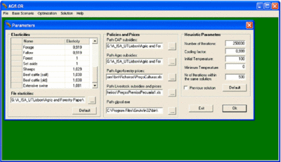
The GUI helps the user to specify and input policy changes, product prices and supply elasticity, and subsidies for each agroforestry and livestock activity.
- Design
The GUI provides guidance to define simulated annealing parameters.
- Choice
The LP solver and the simulated annealing algorithm and the GUI help select policies.
- Monitor
No support is provided.
Data and data models
Typical spatial extent of application
The system may be used both for regional analysis. It may address both national and international policy contexts.
Forest data input
The system uses gis information (vectorial) to display farm-type regional units. It further uses economic data (e.g. prices, supply elasticity, subsidies)
Type of information input from user (via GUI)
The uses inputs data on policy changes, product prices and supply elasticity, and subsidies for each agroforestry and livestock activity.

Models
A Positive Mathematical Programming model is used to calibrate mathematical programming models according to observed behaviours during a reference period. It aims to assess economic, technical and institutional scenarios associated with changes in policies, relative prices, technologies and availability of inputs.
Decision Support
Definition of management interventions
Not applicable
Typical temporal scale of application
The system addresses mostly strategic policy issues
Types of decisions supported
- Management level
- strategic decisions
- planning decisions
- command decisions
- control decisions
- coordination decisions
- decision making situation
- unilateral
- collegial
Decision-making processes and models
AGfLOR uses a linear programming model and a simulated annealing meta-heuristic.
Output
Types of outputs
Results are reported in tables and in maps.

Spatial analysis capabilities
The system has spatial reporting capabilities. Yet it does not include spatial analysis functionalities. It provides standard data import/export formats (GIS, spreadsheet, relational database)
Abilities to address interdisciplinary, multi-scaled, and political issues
The system takes as inputs biophysical, economic and policy information.
System
System requirements
- Hardware requirements: 2 GHz Pentium IV, 1024 Mb of RAM, 250 Mb of hard disk, CD-ROM reader
- Operating Systems: Windows 2000, Windows XP or Windows Vista
- Other software needed: the user does not need to acquire additional software.
- Development status: completed
Architecture and major DSS components
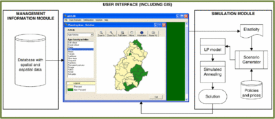
- AGfLOR is a desktop application with a modular structure. It was developed with software Ms VB.NET.
- The system includes a MS Access 2003 relational database (BD_INTERREG_AGRÍCOLA), Ms Excel 2003 spreadsheets, an LP matrix generator, a simulated annealing module and a report generator. It further includes freeware (GIS and LP solver). A GUI ties all modules together to provide the user-schema.

Usage
Government use (Portuguese Ministry of Agriculture Regional Office of Alentejo (DRAPAL))
Computational limitations
Run time is impacted mostly by the number of farm types, agroforestry activities and simulated annealing parameters.
User interface
AGfLOR has a standard Windows GUI. Thoughtful use of the system requires some forest management planning and agricultural economics background.
Documentation and support
The graphical user interface provides access to the AGfLOR users' manual:
Borges, P., J. G. Borges e S. Marques. 2007, Manual de Utilização Sistema de Apoio à Decisão AGfLOR Documento Técnico n.º 07/07, Grupo de Economia e Gestão dos Recursos Naturais, Lisboa , Portugal
Installation
Simple Windows guided installation.
References
Cited references
- ↑ Borges P.J., Fragoso R., Garcia-Gonzalo J., Borges J. G., Marques S. and Lucas, M.R. 2009. Assessing impacts of Common Agricultural Policy changes on regional land use patterns with a decision support system. An application in Southern Portugal. Forest Policy and Economics, doi: 10.1016/ j.forpol.2009.09.002
- ↑ Borges P.J., Fragoso R., Garcia-Gonzalo J., Borges J. G., Marques S. and Lucas, M.R. 2009. Assessing impacts of Common Agricultural Policy changes on regional land use patterns with a decision support system. An application in Southern Portugal. Forest Policy and Economics, doi: 10.1016/ j.forpol.2009.09.002
- ↑ Borges P.J., Fragoso R., Garcia-Gonzalo J., Borges J. G., Marques S. and Lucas, M.R. 2009. Assessing impacts of Common Agricultural Policy changes on regional land use patterns with a decision support system. An application in Southern Portugal. Forest Policy and Economics, doi: 10.1016/ j.forpol.2009.09.002
- ↑ Borges P.J., Fragoso R., Garcia-Gonzalo J., Borges J. G., Marques S. and Lucas, M.R. 2009. Assessing impacts of Common Agricultural Policy changes on regional land use patterns with a decision support system. An application in Southern Portugal. Forest Policy and Economics, doi: 10.1016/ j.forpol.2009.09.002
External resources
Borges P.J., Fragoso R., Garcia-Gonzalo J., Borges J. G., Marques S. and Lucas, M.R. 2009. Assessing impacts of Common Agricultural Policy changes on regional land use patterns with a decision support system. An application in Southern Portugal. Forest Policy and Economics, doi: 10.1016/ j.forpol.2009.09.002

