Difference between revisions of "Monsu"
m (Reverted edits by Acovefonyva (Talk) to last revision by Tronei) |
|||
| Line 1: | Line 1: | ||
| − | + | {{DSS description, Name, responsible organisation and contact person | |
| − | + | |Name=Monsu | |
| − | + | |Acronym=Monsu | |
| − | + | |Responsible organisation=Joen Forest Program Consulting | |
| − | === | + | |Type of the owner organization=IT company |
| − | Monsu is a calculation and planning software that was developed in Finland in order to be used within multiple-use forestry. It covers scheduling plans generation, numerical optimization and results graphical visualization. | + | |Institutional framework=commercial product |
| − | + | |Contact person for the Wiki=Timo Pukkala | |
| − | + | |Contact e-mail for the Wiki=timo.pukkala at uef.fi | |
| − | + | |Contact person for the DSS=Timo Pukkala | |
| − | + | |Contact e-mail for the DSS=timo.pukkala at uef.fi | |
| − | + | |Additional information= | |
| − | + | }} | |
| − | + | {{DSS description, Scope of the tool | |
| − | + | |Description=Monsu is a calculation and planning software that was developed in Finland in order to be used within multiple-use forestry. It covers scheduling plans generation, numerical optimization and results graphical visualization. | |
| − | + | |Modelling dimension=Economical indicators, Forest indicators, user defined | |
| − | + | |Temporal scale=long term (strategic), medium term (tactical) | |
| − | + | |Spatial context=spatial with neighbourhood interrelations, spatial with no neighbourhood interrelations, non spatial | |
| − | + | |Spatial scale=regional/national level, forest level, stand level | |
| − | + | |Objectives dimension=multiple objectives | |
| − | + | |Goods and services dimension=market wood products | |
| − | + | |Forest management goal=biomass estimation, carbon sequestration, economic evaluation, forest fuel harvesting, silvicultural regime, yield prediction, wood supply planning, user defined | |
| − | + | |Supported tree species=any | |
| − | + | |Supported silvicultural regime=even-aged, uneven-aged/natural regeneration, uneven-aged/plantation, coppice system, agroforestry, user defined | |
| − | + | |Decision making dimension=single decision maker | |
| − | + | |Additional information= | |
| − | + | }} | |
| − | + | {{DSS description, Concrete application | |
| − | + | |Number of users=N/A | |
| − | + | |Number of real-life applications=N/A | |
| − | + | |Utilisation in education: kind of utilisation (demo, use)=used by students | |
| − | + | |Additional information= | |
| − | + | }} | |
| − | + | {{DSS description, Installation and support | |
| − | + | |Status=used (stable and not upgraded/not upgraded recently) | |
| + | |Accessibility=restricted access | ||
| + | |Commercial product=Yes | ||
| + | |Deployment cost=N/A | ||
| + | |Price= | ||
| + | |Additional information= | ||
| + | }} | ||
| + | {{DSS description, Data, data model and data management | ||
| + | |Input data requirements=Forest inventory data | ||
| + | |Format of the output data=text file, table, graph, map, 3d-visualization, pre-defined report, pre-programmed summaries | ||
| + | |Data validation=missing/wrong data, error handling, logging facilities | ||
| + | |Format of the output data=text file, XML, table, graph, map, 3d-visualization, pre-defined report, pre-programmed summaries | ||
| + | |Internal data management=memory only, temporary files | ||
| + | |Database=N/A | ||
| + | |GIS integration=N/A | ||
| + | |Data mining=N/A | ||
| + | |Spatial analysis= | ||
| + | |Additional information= | ||
| + | }} | ||
| + | {{DSS description, Models and methods, MBMS, decision support techniques | ||
| + | |Forest models=growth models | ||
| + | |Ecological models=game management, habitat suitability, biodiversity, conservation value | ||
| + | |Social models=monetary values of non-market products and services | ||
| + | |MCDM methods=N/A | ||
| + | |Optimisation package=other | ||
| + | |Optimisation algorithm=linear programming, metaheuristic algorithm | ||
| + | |Risk evaluation=N/A | ||
| + | |Uncertainty evaluation=N/A | ||
| + | |Planning scenario= | ||
| + | |Additional information= | ||
| + | }} | ||
| + | {{DSS description, Support of knowledge management process | ||
| + | |Integrated KM techniques to identify and structure knowledge= | ||
| + | |Integrated KM techniques to analyse and apply knowledge= | ||
| + | |Additional information= | ||
| + | }} | ||
| + | {{DSS description, Support of social participation | ||
| + | |Stakeholder identification support= | ||
| + | |Planning criteria formation support= | ||
| + | |Planning process monitoring and evaluation= | ||
| + | |Planning outcome monitoring and evaluation= | ||
| + | |Additional information= | ||
| + | }} | ||
| + | {{DSS description, User interface and outputs | ||
| + | |User access control=No | ||
| + | |Parameterised GUI=Yes | ||
| + | |GUI technology=other | ||
| + | |Additional information= | ||
| + | }} | ||
| + | {{{DSS description, System design and development | ||
| + | |Software development methodology= | ||
| + | |Methods applied in the requirement phase= | ||
| + | |Methods applied in the design phase= | ||
| + | |Methods applied in the construction phase= | ||
| + | |Methods applied in the testing phase= | ||
| + | |Methods applied to ensure software quality= | ||
| + | |Development start year= | ||
| + | |Number of development years (100% equivalent)= | ||
| + | |Development team size=2 | ||
| + | |Team profiles= | ||
| + | |Number of forest specialists in the development team= | ||
| + | |Number of users participating in specification= | ||
| + | |Additional information= | ||
| + | }} | ||
| + | {{DSS description, Technological architecture, integration with other systems | ||
| + | |System type=stand-alone GUI | ||
| + | |Application architecture= | ||
| + | |Communication architecture= | ||
| + | |Operating system=Windows | ||
| + | |Programming language= | ||
| + | |Scalability=No | ||
| + | |Interoperability= | ||
| + | |Integration with other systems= | ||
| + | |Related tools= | ||
| + | |Additional information= | ||
| + | }} | ||
| + | {{DSS description, Ongoing development | ||
| + | |Adaptation effort (man years)=N/A | ||
| + | |Additional information= | ||
| + | }} | ||
| + | {{DSS description, Documentation | ||
| + | |Manual=No | ||
| + | |Technical documentation=No | ||
| + | |Additional information= | ||
| + | }} | ||
| + | = ADDITIONAL INFORMATION (needs to be migrated using the "edit with form" link) = | ||
=== Scope of the system === | === Scope of the system === | ||
Monsu forest management planning follows three steps <ref>PUKKALA T. 2004. Dealing with Ecological Objectives in the Monsu Planning System. ''Silva Lusitana''. nº especial: 1 - 15.</ref>: | Monsu forest management planning follows three steps <ref>PUKKALA T. 2004. Dealing with Ecological Objectives in the Monsu Planning System. ''Silva Lusitana''. nº especial: 1 - 15.</ref>: | ||
Revision as of 21:48, 31 August 2012
Template:DSS description, Name, responsible organisation and contact person Template:DSS description, Scope of the tool Template:DSS description, Concrete application Template:DSS description, Installation and support Template:DSS description, Data, data model and data management Template:DSS description, Models and methods, MBMS, decision support techniques Template:DSS description, Support of knowledge management process Template:DSS description, Support of social participation Template:DSS description, User interface and outputs {Template:DSS description, System design and development Template:DSS description, Technological architecture, integration with other systems Template:DSS description, Ongoing development Template:DSS description, Documentation
Contents
- 1 ADDITIONAL INFORMATION (needs to be migrated using the "edit with form" link)
ADDITIONAL INFORMATION (needs to be migrated using the "edit with form" link)
Scope of the system
Monsu forest management planning follows three steps [1]:
- Management scheduling
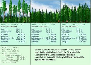
- The forest under planning is divided into compartments, and each compartment is inventoried in the field. The field data (from both living and dead trees are imported to a compartment database. Then, alternative treatment schedules are simulated for the stand compartments. Each treatment schedule is described by treatments attached to it, timber removals, and development of the growing stock characteristics
- Planning model
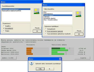
- For this, Monsu has a planning model writer and various optimisers. The first combines information on decision maker's objectives, and production possibilities of the before simulated treatment schedules of stands. The optimisers can use linear programming and goal programming models, as well as utility theoretic problem formulations, solved with heuristics.
- Solution presentation
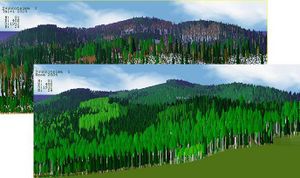
- Monsu includes a visual interface and a landscape visualiser to interactive optimisation and also useable after it
System origin
- It was developed by Timo Pukkala and Heikki Parikka.
- Monsu latest version was released in February 2004 in Finland.
- It has been used as an educational, research and even practice planning tool.
- Commercial, but inexpensive. It is sold by the Finnish company Joen Forest Program Consulting (JFPC).
Support for specific issues
Developed towards a multifunctional forest, Monsu not only estimates timber yields, it also calculates variables describing non-wood forest products and services like berry and mushroom yields, and scenic beauty and recreation scores. Furthermore, so much attention has been paid on its capabilities in ecological planning.
Support for specific thematic areas of a problem type
- Silvicultural
- Certification
- Conservation
- Development choices / land use zoning
- Policy/intervention alternatives
Capability to support decision making phases
- Intelligence:
- The current conditions of the forest can be analysed and the management goals established.
- Design:
- The simulation tool run the different management possibilities among the restrictions imposed by the input data.
- Choice:
- Heuristic tools are used in order to ensure the best management option is the chosen one by the manager.
- Monitor:
- No implemented.
Related systems
Data and data models
Typical spatial extent of application
Forest level.
Forest data input
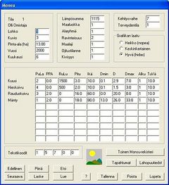
Inventoried field data are required. Furthermore, not only living trees must be inventoried, also dead trees, because they are considered important for biodiversity. This data can be both introduced via GUI or imported from other software files.
Type of information input from user (via GUI)
Management goals have to be specified, and then weighted by the use of the bar charts, in order to establish the manager's preferences. More than one goal can be selected.
Models
Forest models
Timber, berry and mushroom yield models and biodiversity are implemented within Monsu.
Social models
Scenic beauty and recreation scores are taking into account.
Decision Support
Definition of management interventions
At first there is a prescription writer that defines the scheduling possibilities. Then, the user is able to change the weight within the goals proposed in order to reach an available solution.
Typical temporal scale of application
Usually used at tactical level.
Types of decisions supported
- Management level
- strategic decisions
- operating control decisions
- Management function
Decision-making processes and models
The optimization methods implemented comprises mathematical programming methods:
And some heuristic algorithms:
- Genetic algorithms
- Tabu search
- Simulated annealing
- Random ascent
- HERO
- A combination of HERO and Simulated annealing
(The mathematical programming methods require Lindo extra-software to be acquired separately)
Output
Types of outputs
Monsu generates as final report a forest management plan, in a word processing format in order to be printed or edited.
The solution outputs are shown with a visual interface and a landscape 3D visualiser.
Spatial analysis capabilities
It is allowed to optimize some spatial features, like concentration or dispersion of harvesting events, and the creation or protection of old-forest or some fixed species areas.
Spatial analysis is allowed with the use of the visualization tool, useful for landscape level.
No cartographic tools are implemented, but information can be easily transferred in order to be used in any GIS software (TOPOS, MapInfo)
Abilities to address interdisciplinary, multi-scaled, and political issues
Being a multi-use forest management addressed tool, it has the capability of helping to solve ecological, technical, economic and social interactions.
System
System requirements
- Operating Systems: Microsoft® Windows® OS
- Currently the 4.0 version is the most recent.
- Lindo mathematical programming software is required in order to use some optimization methods.
- In order to allow geographic analyses through maps some GIS tool must be available.
Usage
Monsu was originally developed for educational use, but it is also used in research and practical planning.
User interface
Monsu interface is visual and easy to understand, thanks to the use of modern design methods.
Documentation and support
Monsu website provides contact information in order to solve user's doubts.
References
Cited references
- ↑ PUKKALA T. 2004. Dealing with Ecological Objectives in the Monsu Planning System. Silva Lusitana. nº especial: 1 - 15.


