Participation in forest planning in Sardinia
General case description
Brief overview
The participatory process was conducted as a part of the forest landscape management plan "Distretto Arci-Grighine" (Agnoloni et al. 2009, Ferretti et al. 2010). It was produced within the framework of the activities established in the Protocol of Agreement between the Agricultural Research Council (C.R.A.) and the Department of Environment Preservation of Sardinia Region - Headquarters of Cagliari (planning organization).
The Arci-Grighine district (39° 42’ 7’’ North; 8° 42’ 4’’ East) is localized in the Centre-East area of the Sardinia island. The district has a total surface of 55,183 ha, corrisponding to the 2.3% of the Sardinia surface. The population is 26,207 (2001 Census) for a density of about 0.47 persons/ha. The district comprises 21 municipalities. The forest surface is 18,349 ha divided in 43.2% ha of broadleaf forests, 16.6% of evergreen forests, 39.6% of Mediterranean forests and 0.6% of mixed forests. Considering that the forests are 33.3% of land use of Arci-Grighine district, the other land uses are agricultural land (36.1%), grassland (10.7%), shrub land (12.7%), and agro-pastoral land (5.2%).
The decision makers was the Regional Government of Sardinia.
The aims of the participatory process in the study case were (Cantiani e De Meo 2007):
- to define, through study cases, a procedure capable of integrating participation into landscape forest planning and to develop a method suitable for all the different situations in Italy.
- to evaluate the perception of the forest and of forest management within the local communities;
- to integrate the traditional knowledge with the technical content of the plan;
- to make the population aware of the planning process;
- to carry out the mapping of the stakeholders;
- to involve, through a targeted reach-out, stakeholders who would otherwise not have been able to voice their concerns.
Contents
Organization
Main steps of the participatory process
- 1. context analysis
- 2. stakeholders’ assessment
- 3. planning participation group definition
- 4. method definition
- 5. tools selection
- 6. field survey and data collection
Problem structuring
A participation process was launched based on the consultation by the Planning Participation Group (CRA, Sardinia Region). The launch of the participation was initially made concrete during the detailed informing of the institutional individuals involved and of the citizens, followed by the consultation phase itself. The local community was involved in the entire planning procedure (from march 2009, in progress): from preliminary surveys to the definition of the intervention guidelines of the forest plan policy at landscape level.
Intelligence
Stakeholders
The stakeholders’ identification process was iterative. Starting with institutional respondents, previously unknown representative respondents were also identified. Following the first interviews, the snowball effect ensured that more interviewees were carried out. The main advantage of this type of sampling, known as "Snowball sampling" or "Referall sampling", is its limited cost and sample size.
Objectives Preferences Information
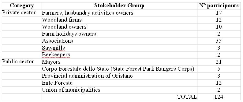
The involvement of the stakeholders was obtained through interviews, aimed at assessing the perception and knowledge of the silvo-pastoral systems, to highlight problems and opportunities and to collect proposals for future land development theories. The questions were formulated according to the following topics: the value and main functions of the woodland; knowledge of the forest value chain and the current situation within the sector; grazing and the relationship between pastures and forest; the potential for agriculture; the value attributed to landscape and perception of changes in the landscape, the population’s bond with the territory; relations between the population and the institutions. The interview, comprised of 97 questions, was submitted to 124 stakeholders subdivided into various categories as shown in the table.
Design
Alternatives
The consultation consists of the engagement of the institutional players and some stakeholders in work groups to discuss the management strategy outlined in the project’s draft and to jointly finalise the plan. People responsible for the planning process outlines the synthetic managing forms (identified planning proposals), in the form of a draft, in order to submit them to the representatives of the local communities (members of the institutions and some stakeholders).
Choice
Usage of DSS
Usage of models, methods and tools
Monitoring
The success of the project is monitored by the Planning Participation Group which is connected to the main stakeholders. This exchange of information allows the Participation Group to monitor the satisfaction of the stakeholders.
References
Cited references
- Agnoloni S, Bianchi M, Bianchetto E, Cantiani P, De Meo I, Dibari C, Ferretti F, (2009). I piani forestali territoriali di indirizzo: una proposta metodologica. Forest@ 6 (1): 140-147.
- Cantiani M.G., De Meo I., (2007). La partecipazione pubblica nel piano forestale territoriale. Oral presentation at the Strategic National Project “Riselvitalia”- Le esperienze nel centro sud Italia: presentazione dei risultati. Potenza, 19-21 giugno 2007
- Ferretti F., Di Bari C., De Meo I, Cantiani P, Bianchi M. (2010). ProgettoBosco, a Data-Driven Decision Support System for forest planning. To appear in Mathematical and Computational Forestry & Natural-Resource Sciences (MCFNS).
